References
Customers of different specializations use our professional services for map visualizations, spatial analyses and geographic information systems.
Customers of different specializations use our professional services for map visualizations, spatial analyses and geographic information systems.

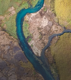
The aim of the project is to identify critical places in the cultural landscape, where human activities prevail over natural ones, which are most vulnerable to flash floods. In doing so, we recognise the ecological and economic risk and, of course, the potential threat to human life and health.

On the basis of mathematical modelling of the impact of scenarios of measures in the basins (560 profiles) on the peak flow and design flood wave caused by causal precipitation with a probability of recurrence of 100 years, the effectiveness of natural measures in forests, agricultural land and urbanised areas was evaluated and the need for implementation of technical measures proposed in the flood risk management plans of individual sub-basins of the Slovak Republic was demonstrated in order to meet the objectives of Article 2.1.1 of Regulation (EC) No. 1 of the Flood Risk Assessment and Management Directive - to reduce the adverse effects of floods on human health, the environment, cultural heritage and economic activity.

Development of a Web GIS application containing several GIS and modelling tools for the operational solution of water management tasks, which serves as the main tool for testing mapping, analytical and reporting services integrated into the "TIS" portal of the Slovak Water Management Company.
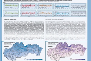
The main objective of the project was to create a comprehensive cartographic work Climate Atlas of the Slovak Republic in printed form and in the form of a WEB GIS application.
The aim of the project was the development of an expert operational system for the determination of hydrological and climatic design variables for flood protection of towns and villages in the Slovak Republic.
Within the framework of the project, in cooperation with partners NLC-Zvolen and ŠGÚDŠ Bratislava, a comprehensive complex simulation and modelling tool was developed, which includes tools and an extensive database of input geographic data for rainfall-runoff modelling, erosion modelling and pollution propagation, adapted to Slovak physical-geographical conditions and providing extensive possibilities for assessing and predicting changes in the behaviour of the entire catchment system depending on natural and anthropogenic influences. The modelling tool has been used in several projects and tasks (e.g. Hydrofor (HUSKROUA/1101/262), National Forestry Centre, SVP - Assessment of the potential impact of existing and proposed preventive measures in the catchment on the achievement of the objectives of the flood risk management plan - modelling of rainfall-runoff processes and hydrological response of the catchment to defined scenarios).
The subject of the project were the following activities:
- Design and implementation of a GIS server environment
- Design of the structure and implementation of the geodatabase
- Cartographization and publication of map services for the needs of the Water Information System
- Development of geoprocessing tools and their publication through standardised services for use in web applications.
- Design and implementation of standard WEB-GIS functionalities
- Design and implementation of specialised GIS functionalities for the needs of the Water Information System via web applications

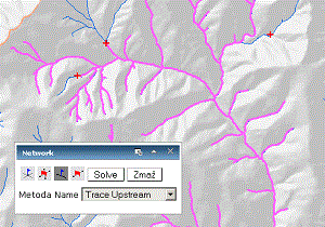
In cooperation with KVHK SvF STU Bratislava, a tool (distributed hydrological model) was developed to model hydrological processes in catchments without observation of hydrological elements. The conceptual structure of several existing hydrological models was used as a basis for the development of the model. Existing solutions were modified to be suitable for modelling runoff from precipitation and snowmelt in our physical-geographical conditions. Combining physical and empirical relationships, we modeled the following hydrologic processes: precipitation, snow accumulation and snowmelt, interception, accumulation in surface depressions, surface runoff, infiltration, evapotranspiration, percolation, hypodermal runoff, baseflow, and water balance in the root and saturated zones.
Development of a communication system and integration of data from automatic hydrological, rainfall and meteorological stations, satellite, radar and other relevant information on the basis of a database server. Development of systems for user and administrator management of data areas. GIS applications for the POVAPSYS central display interface with tools for displaying normal and crisis conditions for the main hydrological characteristics.
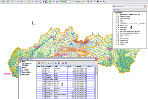
The project focused on the creation of a spatial database and application solution for the needs of the European Water Directive. The database was created by integrating and modifying existing SHMÚ resources and creating new data objects with a focus on ensuring spatial and logical integrity. Primary attention was paid to all data with a direct or indirect link to water bodies, broken down by landscape structures.
Within the framework of the project, erosion and accelerated surface runoff hazards were modelled for the whole of Slovakia on the basis of detailed databases characterising individual geosystem elements, with output into cartographically expressed proposals for measures to improve the retention capacity of the territory and proposals for anti-erosion measures in individual sub-basins. The outputs are part of the documents Water Plan of the Slovak Republic, Preliminary Flood Risk Assessment.
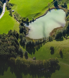
The task was focused on a comprehensive landscape-ecological and water management assessment of the processes associated with silting of the reservoir.
- Geochemical Atlas of Slovakia: natural radioactivity of rocks
- Geochemical Atlas of Slovakia: forest biomass
- Geochemical Atlas of Slovakia: Groundwater
- Geothermal Atlas of Slovakia 1994 - 1999 Map of water protection - set of maps of Slovakia at a scale of 1:50000